
An Earthquake Shook Maine 10 Years Ago This Week
10 years ago this week, on October 16, 2012, Maine was rocked by a pretty good-sized earthquake! The earthquake was in northern York County, with an epicenter near the Waterboro-Hollis town line. This quake was a 4.5 on the Richter Scale. This looks to be one of the largest Maine-based earthquakes ever recorded and could be felt as far away as New Jersey!

Who Felt the 2012 Maine Earthquake?
"The earthquake was widely felt across central and southern New England from Bangor, Maine to Hartford, Connecticut, with scattered reports as far as northern New Jersey and central New York State. By Wednesday morning, over 16,000 reports had been submitted to the U.S. Geological Survey's online site. The regional intensity map shows a small area near the epicenter with peak intensity V, and most of the felt area reporting intensities II to III."
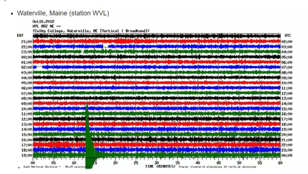
Check out the seismic recording. Can you see the spike?!
What is the Biggest Earthquake That Ever Happened in Maine?
Historically, the biggest earthquake known in Maine took place in 1904. This was a big one- we think a 7.0 on the scale! The largest officially measured earthquake in Maine was in 1973, and felt in Northern Oxford County. This was from an earthquake with an epicenter just north of us in Quebec.
Check out the moment the 2012 earthquake hit during a town meeting in Waterboro.
Here's a news report on the quake.
Maine does get small earthquakes quite often. In fact, we've had four little quakes this month alone. You can track Maine's earthquakes here.
The 10 Safest Places in Maine to Live Right Now
Gallery Credit: Joey
The Ultimate Guide to Maine Specialty License Plates
More From Q97.9


![Waldo County Rocks! No, Really, They Had an Earthquake [VIDEO]](http://townsquare.media/site/697/files/2017/06/corn.jpg?w=980&q=75)
