Some Forecast Models Promising Huge Snowfall for Portions of Maine This Weekend
Let's call it a stand off of sorts. The stand coming in the form of snowfall totals and where the snow will fall from different forecast models.
There's only one certainty as of right now, there's a storm coming. It could bring substantial rain and more powerful winds or it could bring an absolute pounding of snow to Maine as well.
So who do you trust?
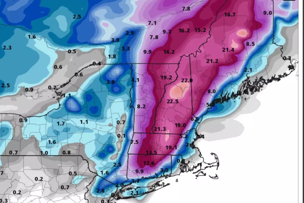
Shared on Twitter by Robert LaRoche, the EURO model has this weekend's storm throwing snow haymakers at the mountains as well as northern and most of southern Maine and New Hampshire.
We're not kidding, the EURO snowfall totals are nuts, with predicted totals between 12-20 inches. If you live along the coast or eastern Maine, you're still likely to see snow from this storm but only in the 2-5 inches range.
So do you trust the EURO?
Maybe the GFS model is more your thing and if it is, this weekend is more of a rainmaker and less of a haymaker.
Eastern Maine and portions of northern Maine won't escape snow, but rather than 12-20, the GFS calls for more reasonable amounts of 6-12. The GFS also predicts western/southern Maine won't see any snowflakes at all. And it looks like New Hampshire the same situation.
Those who have yet to pull out the shovels or test the snowblower, you can rejoice. Do you trust the GFS?
Typically when these two widely used models disagree this much, the results often lie somewhere in the middle. It's looking more and more likely that all of Maine will see at least a little bit of snow this weekend, with northern and eastern Maine seeing piles of it.
The storm is expected to arrive Saturday into Sunday so there's still time for predictions to change and models to come together.
Winter is coming.
10 Essential Items to Survive a Maine Winter
More From Q97.9